Ponds and dams
The Tenas mine would keep its acid-generating waste rock under water in three ponds, held by four earth dams on a hillside above the Telkwa River. This page describes the ponds and dams, how their liners hold water and let it seep, where our flood maps come from, and what Telkwa Coal's own study says would happen if a dam failed.
The Tenas mine would keep acid-making waste rock under water, forever, in ponds held back by earth dams above the Telkwa River. This page covers how the ponds leak and what a dam failure would do.
The Tenas Project stores potentially acid-generating (PAG) waste rock subaqueously in three management ponds impounded by earth-fill dams above the Telkwa River; a fourth dam impounds the Tenas Control Pond (TCP). This page summarises dam geometry, liner design and seepage, the provenance of our flood overlays, and the consequences estimated by Telkwa Coal's 2021 dam breach assessment (DBA).
In brief
Three of the dams hold back ponds where the Tenas mine would store its acid-generating waste rock under water, permanently. The fourth holds a settling pond below them. Each pond floor carries a 30 cm liner of soil mixed with bentonite clay, which lets water seep slowly into the ground beneath, about 1,600 cubic metres a day by 2024 figures. In 2021 Telkwa Coal's engineers, SRK Consulting, modelled what would happen if the dams failed. Their study estimates that a failure would put up to about 200 more people in a flood's path, most of them in the Village of Telkwa, 11 kilometres downstream. Our flood maps are that study's figures. The same study, unchanged, was filed again in 2026.
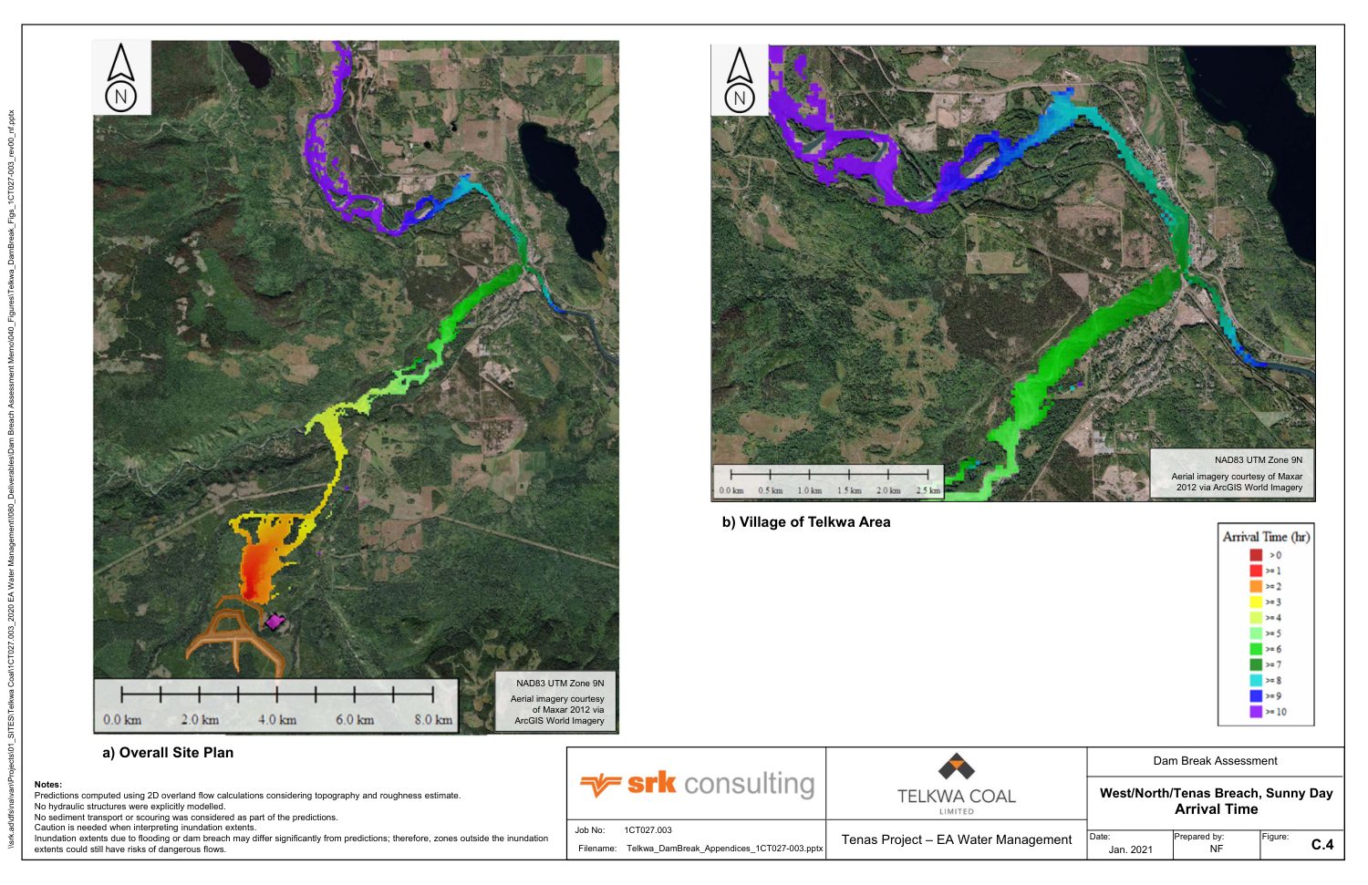
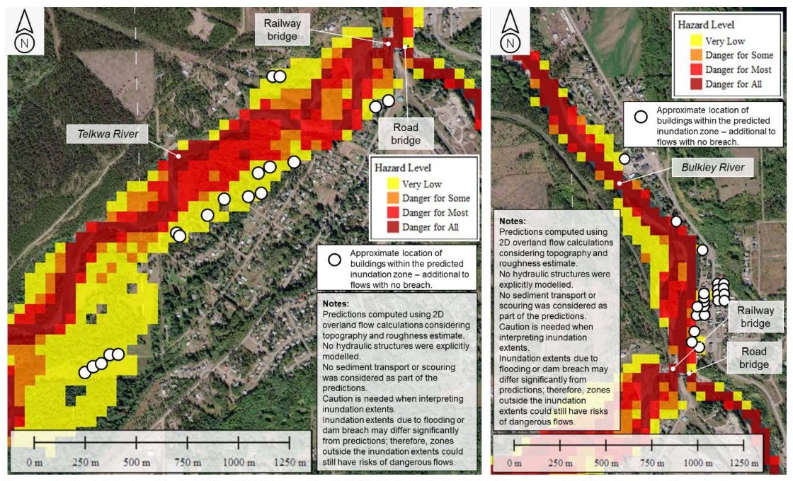
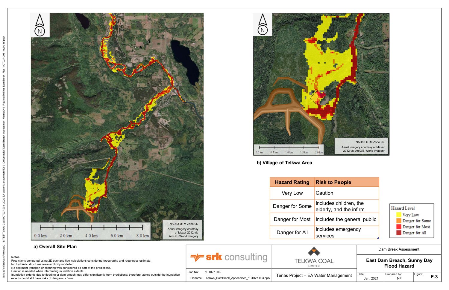
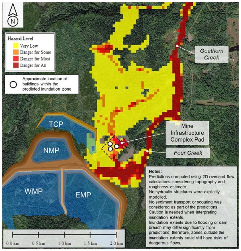
All four figures come from Telkwa Coal's Dam Breach Assessment Report of April 2021. That report says its predictions "may vary significantly" from what would happen.
What the ponds and dams are
The Tenas mine would dig up rock that turns water acidic when exposed to air. The plan keeps that rock under about two metres of water for good, in three "management ponds" built on a hillside between Tenas Creek and Goathorn Creek. An earth dam holds each pond. A fourth dam holds the Tenas Control Pond, which sits downhill and collects what flows out of the other three. Source: Dam Breach Assessment Report, SRK, Apr 2021, p. 12.
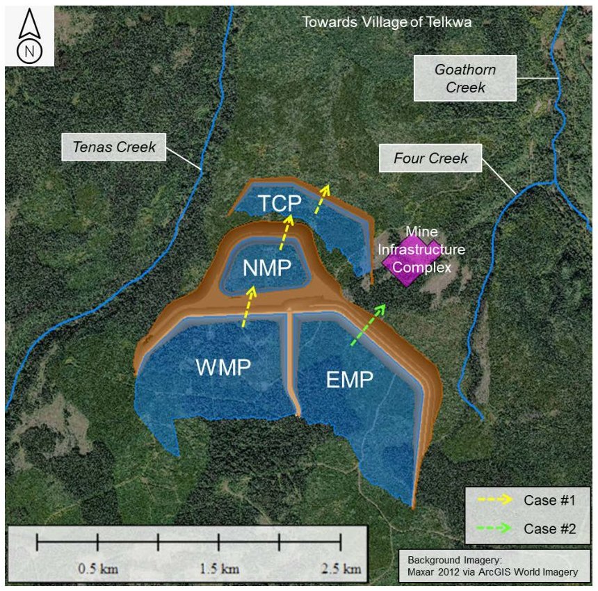
| Dam | Length | Greatest height | Storage to crest | Holds |
|---|---|---|---|---|
| West | 1,511 m | 37 m | 36.2 million m³ | Waste rock under water |
| East | 3,225 m | 40 m | 17.5 million m³ | Waste rock under water |
| North | 1,173 m | 27 m | 4.1 million m³ | Waste rock under water |
| Tenas Control Pond | 1,876 m | 18 m | 2.3 million m³ | Water and settled sediment |
From Table 2-1 of SRK's study. Rock fills most of each management pond's storage; water that could escape is a layer on top. SRK notes that the final mine plan lowered the West, East and control pond crests by two metres after modelling was done. Source: Dam Breach Assessment Report, SRK, Apr 2021, p. 15; Dam Breach Assessment Report, SRK, Apr 2021, p. 47.
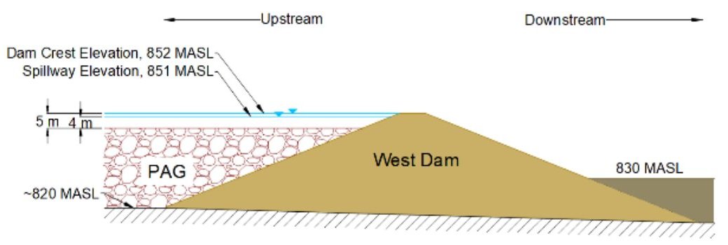
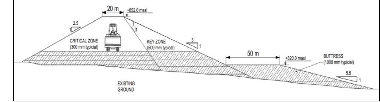
Dams are to be built of waste rock and local soil: "well-graded sands, silts, and gravels near the surface, with larger quantities of fine sands at greater depths". Source: Dam Breach Assessment Report, SRK, Apr 2021, p. 15.
The ponds and dams year by year, from the engineering drawings →
Pond liners and seepage
The management ponds are designed to leak slowly. Each pond floor, and the inner face of each dam, carries a liner of local soil mixed with bentonite, a clay that swells when wet. The liner holds back enough water to keep the waste rock submerged, and lets a planned amount seep into the ground below. In answer to a public comment, Telkwa Coal put it this way: “Telkwa Coal has never stated that the ponds will not leak, in fact the opposite is true; they will leak at a controlled rate by the placement of engineered liner made of bentonite and soil.” Source: Public comments 1–559 with company responses, Nov 2022, comment 81-2.
| # | Layer | Thickness | Permeability, m/s |
|---|---|---|---|
| 1 | Water cover | at least 1 m, by design | — |
| 2 | Acid-generating waste rock, under water | tens of metres | 1×10⁻⁵ |
| 3 | Heavy synthetic fabric that protects the liner | a few millimetres | does not seal |
| 4 | Soil-bentonite liner | 30 cm, laid in two layers | 1×10⁻¹⁰ or less, a target |
| 5 | Natural ground: stiff clay, sand and gravel | 30 m or more under most of the ponds | 1.9–3.0×10⁻⁶ |
| 6 | Sedimentary bedrock of the Skeena Group | — | 3.6×10⁻⁷ |
| 7 | Drain inside each dam, recommended by SRK | — | drains |
Permeability is the speed at which water moves through a material when pushed by a slope of one metre per metre. Each step in the power of ten is a tenfold change: the liner is meant to be 20,000 to 30,000 times tighter than the ground beneath it. Sources: Liner Design and Construction Methodology, SRK, p. 4 (rows 4–6), p. 3 (row 1), p. 14 (ground), p. 16 (fabric); Management and Control Ponds Stability Assessment, SRK, Apr 2021, p. 30 (row 2), p. 11 (row 7).
Extent of lining
- North and East ponds. Each pond's floor and the inner face of its dam are lined. Source: Water response, Part 1 of 9, Jul 9, 2026, p. 34.
- West pond. This pond fills part of the mined-out pit and spreads onto the ground beside it. Lining covers the part outside the pit and the slope of loose soil above bedrock inside it. The pit's rock floor and south rock wall have “No liner prescribed”. SkeenaWild's reviewers estimate that about 57 percent of this pond is lined. Telkwa Mining plans to build its liner after Year 5. Source: Water response, Part 1, p. 34, p. 46; SkeenaWild technical review, Jul 2022, p. 30.
- Tenas Control Pond. This pond holds water that has run off or through mine waste, and the sediment it carries, but no waste rock. It is lined with an asphalt-based membrane. Source: Water response, Part 1, p. 33.
Construction and permeability target
Crews loosen the top 15 cm of natural soil, spread bentonite over it and mix it in. They lay a second 15 cm of soil, treat it the same way, and compact the 30 cm liner. A heavy synthetic fabric goes on top to keep waste rock from puncturing it. SRK compared the fabric with a one-metre cover of soil, and chose the fabric because it costs less and takes up no room in the pond. Source: Liner Design and Construction Methodology, SRK, pp. 15–16.
The liner's permeability of 1×10⁻¹⁰ m/s is a design target. No sample of the Tenas liner has yet been made or tested.
- SRK first calculated 1×10⁻⁹ m/s for a soil with 5 percent bentonite. That is ten times more permeable than the target.
- A laboratory test of bentonite then gave a better figure. On that test, and on “previous experience with a similar northern project”, SRK wrote that 1×10⁻¹⁰ m/s “can be achieved”, and designed to that number. Source: Liner memo, printed p. 4, PDF p. 5.
- Laboratory blends and field trial pads are to prove that target before construction. Source: Liner memo, p. 18.
- BC's environment ministry asked how much the liner's permeability could vary from construction alone. Telkwa Mining's answer was ±15 percent. Source: Water response, Part 1, p. 50.
Seepage estimates
| Case | Seepage, m³ a day |
|---|---|
| The most the ponds can lose in a dry decade and still keep 1 m of water over the rock, by SRK's water balance | 2,800 |
| The same, in an average year | 4,260 |
| No liner, SRK model, 2020 | 6,992 |
| Chosen 30 cm liner, SRK model, 2020 (in brackets, if the ground is more permeable) | 1,736 (2,594) |
| Company's 2024 project case, end of mining: West 836, North 198, East 458, control pond 140 | 1,632 |
| Thicker liners studied in 2024, Option 1 | 745 |
| Thicker liners studied in 2024, Option 2 | 531 |
Sources: Liner memo, p. 3, p. 9, p. 11; Water response, Part 1, p. 35.
At the 2024 figure, about 600,000 cubic metres a year would pass through the pond floors into the ground at the end of mining. That volume fills about 240 Olympic swimming pools. Earlier reports give 1,110 to 1,736 m³ a day, depending on the model.
Our rough check. At the target permeability, water creeps through the liner at about 3 mm a year when pushed only by a slope of one metre per metre. Under 30 m of water-filled rock, a 30 cm liner is pushed about a hundred times harder, so about 30 cm of water passes through each square metre each year. Over 1.9 million square metres of lined floor and dam face, that comes to about 1,700 m³ a day, close to SRK's 1,736. This check shows only that SRK's figure is the right size. The liner cuts seepage by about three-quarters, not by the 20,000-fold difference between liner and ground. We assess that without a liner, the limit is how fast groundwater can carry water away from the ponds, not how fast water can soak into the ground beneath them.
Seepage and creek water quality
Telkwa Mining's 2026 response names seepage as the cause of the predicted water-quality exceedances in two creeks: “the current proposed configuration active water treatment does not affect groundwater seepage which is the causes of elevated POCs in Four and Tenas Creeks.” POCs are parameters of concern, such as selenium, sulphate and nitrite. Source: Water response, Part 1, p. 45.
A tighter liner moves water rather than removing it. Less seeps down, so more pond water leaves over the North pond's spillway to Goathorn Creek. BC's environment ministry pointed out that the water on top of the North pond at times carries more selenium than the water held deeper in the rock, and asked for this trade-off to be modelled. Source: Water response, Part 1, p. 50.
Thicker liners studied in 2024
In 2024 SRK studied a 56 cm soil-bentonite liner under a 30 cm layer of compacted soil. One version added an asphalt-based membrane on the East pond. Either would cut seepage from the waste-rock ponds by half or more. Telkwa Mining's final plan does not adopt them. The thicker liner is held in reserve for the West pond, to be built if monitoring shows a need, and its design is left to the permitting stage. Lining the West pond's bedrock floor also stays open, if the other ponds turn out worse than predicted. Source: Water response, Part 1, pp. 34–35, p. 45.
Liner failure
- Dam stability. SRK modelled a “total breakdown” of the liner. A dam's factor of safety compares the forces holding its slopes in place with those that would make them slide. With the liner gone, the dams fall short of the required 1.5 but stay above 1.3, and “imminent failure would be unlikely”. As a backup against liner failure, SRK recommends a vertical drain inside every dam. Source: Stability Assessment, SRK, Apr 2021, p. 11, p. 46.
- Repair. SkeenaWild's reviewers wrote that “once potentially acid-generating mine wastes are placed over them it will be extremely difficult to locate and repair liner failures.” They called its contingency plan unrealistic, because it means draining a pond and removing its rock. Source: SkeenaWild technical review, p. 36, p. 8.
- Lifespan. The Application gives the control pond's membrane a 50-year life. Telkwa Coal calls that “a nominal time” and cites a manufacturer's guarantee of 150 to 250 years. It says the soil-bentonite liner “has no defined lifespan”. SkeenaWild's reviewers expect the liners to be needed much longer than 50 years, because the model has seepage reaching the creeks faster than it would. Source: Company responses to public comments, SRK, Nov 2022, p. 2; SkeenaWild technical review, p. 8.
Where our flood maps come from
Our map carries a set of dam breach flood overlays. They are figures from one document: Tenas Project Dam Breach Assessment Report, written by SRK Consulting for Telkwa Coal and dated April 2021. Telkwa Coal filed it with its 2022 Application as Appendix 1.0-AA, and again as Appendix 13.11-B. Forty-six of its map figures sit on our map, placed by matching each figure's aerial photograph to today's imagery.
- How SRK made its study. SRK used flood-routing software (FLO-2D) on a grid of 50-metre squares. Outside Telkwa, ground elevation comes from satellite radar data at about 30-metre resolution. Source: Dam Breach Assessment Report, SRK, Apr 2021, p. 16; Dam Breach Assessment Report, SRK, Apr 2021, p. 21.
- What that means for our overlays. Each coloured square on a flood map is 50 metres across. Each coloured area's edge is a model result at that coarseness, and our placement adds an error of 2 to 13 metres on top.
- It is Telkwa Coal's own study. The Environmental Assessment Office (EAO) registry holds no independent dam breach model.
What SRK modelled
SRK chose two failures it judged to have worst consequences, and ran each in fair weather ("sunny day") and during an extreme flood ("rainy day"). Source: Dam Breach Assessment Report, SRK, Apr 2021, p. 13; Dam Breach Assessment Report, SRK, Apr 2021, p. 21.
| Failure | Weather | Water released | Reaches Telkwa in | People, by SRK's estimate |
|---|---|---|---|---|
| West, North and control pond dams fail one after another | Fair | 6.5 million m³ | 6 to 7 hours | About 120 affected |
| Flood | 8.3 million m³ | 3 to 4 hours | About 150 moved to a higher hazard level | |
| East Dam fails towards the mine buildings | Fair | 6.3 million m³ | 7 to 8 hours | Up to 200, among them up to 80 mine staff reached in under 1.5 hours |
| Flood | 7.4 million m³ | 3 to 4 hours |
Water released is the free water in Tables 3-1 and 3-2 of SRK's study; cascade totals are our sums over the three dams. Arrival times count from the start of each model run. Source: Dam Breach Assessment Report, SRK, Apr 2021, p. 25; Dam Breach Assessment Report, SRK, Apr 2021, p. 36; Dam Breach Assessment Report, SRK, Apr 2021, p. 38; Dam Breach Assessment Report, SRK, Apr 2021, p. 39; Dam Breach Assessment Report, SRK, Apr 2021, p. 44.
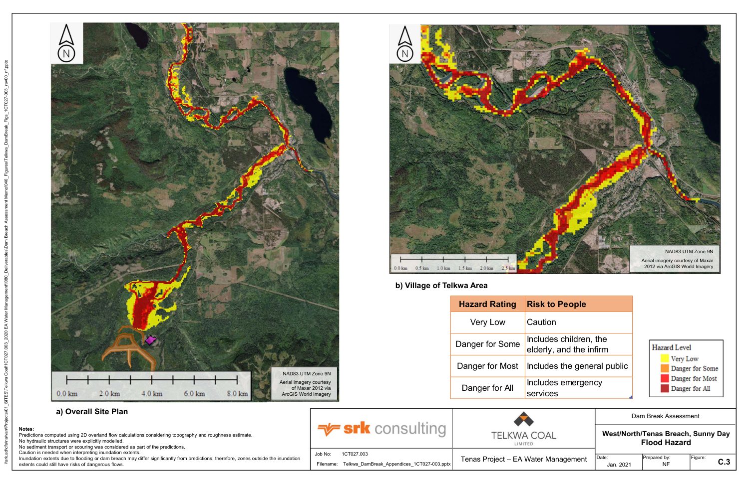
"200 people" means people in a flood's path
SRK's number counts people inside the area a failure would flood, beyond those a natural flood would already reach. It counts people at risk. It is not a count of deaths. Source: Dam Breach Assessment Report, SRK, Apr 2021, p. 9; Dam Breach Assessment Report, SRK, Apr 2021, p. 41.
SRK sorts flooded ground into four hazard classes by water depth and speed:
| Class on the maps | Who is in danger |
|---|---|
| Very Low | "Caution" |
| Danger for Some | "includes children, the elderly, and the infirm" |
| Danger for Most | "includes the general public" |
| Danger for All | "includes emergency services" |
- In fair weather SRK puts "the vast majority" of roughly 120 people in its lowest class. Source: Dam Breach Assessment Report, SRK, Apr 2021, p. 33.
- During an extreme flood much of Telkwa is under water with or without a dam failure. A failure raises hazard for about 150 people, "predominantly" into the two middle classes. Source: Dam Breach Assessment Report, SRK, Apr 2021, p. 46.
- On deaths, SRK wrote in 2024 that "Loss of Life was estimated to be less than 100 for the breach scenarios", counting people in the three higher classes. Source: Water response, Part 7 of 9, Jul 9, 2026, p. 633.
What SRK's study leaves out
SRK's report is plain about its limits.
- Water only. It models water release. It does not model waste rock, sediment or debris moving with it, and assumes debris adds nothing to the hazard, while noting that debris "could result in a significant increase in hazard rating". Source: Dam Breach Assessment Report, SRK, Apr 2021, p. 13; Dam Breach Assessment Report, SRK, Apr 2021, p. 31.
- Fine coal waste. "The potential impacts of the liquefaction of coal rejects and waste material should be considered in later stages of design." Source: Dam Breach Assessment Report, SRK, Apr 2021, p. 47.
- Roads, bridges and ditches. They are not in SRK's model, so "flow redirection unforeseen by the model" may occur. Source: Dam Breach Assessment Report, SRK, Apr 2021, p. 46.
- Sensitivity. With outflow raised by half, the flooded strip widens by up to about 100 metres, "nearly doubling the population at risk" in fair weather. Source: Dam Breach Assessment Report, SRK, Apr 2021, p. 39.
- The environment. SRK expects habitat damage that "will be temporary in nature". It allows that acid drainage products may be in released water. Source: Dam Breach Assessment Report, SRK, Apr 2021, p. 9; Dam Breach Assessment Report, SRK, Apr 2021, p. 44.
- An older mine plan. SRK's model uses the mine plan of December 2020, and its report ends: "An updated dam breach assessment is recommended for final design of all dams." Source: Dam Breach Assessment Report, SRK, Apr 2021, p. 9; Dam Breach Assessment Report, SRK, Apr 2021, p. 47.
What reviewers said, and what changed
BC's mines ministry reviewed these dams in 2022. Its comments became part of EAO's Water Information Request. Source: Water Information Request, Nov 23, 2022, p. 7; Water Information Request, Nov 23, 2022, p. 13; Water Information Request, Nov 23, 2022, p. 14.
- These are tailings dams. Ministry staff wrote that under BC's mining code Telkwa Coal's "processed rock" is tailings and its three management ponds are tailings storage facilities, which "have different minimum requirements than water dams". Telkwa Mining does not accept that label. It answers that it designed its dams to tailings standards anyway. Source: Water response, Part 7 of 9, Jul 9, 2026, p. 632; Water response, Part 7 of 9, Jul 9, 2026, p. 633.
- A rating too low for its numbers. Ministry staff said a study finding more than 100 people at risk "does not clearly support" a rating of "Very High". In 2024 Telkwa Mining's engineers raised all four dams' design rating to "Extreme", its top class, citing a tailings standard and "feedback obtained from the public comment period in 2022". Source: Water response, Part 7 of 9, Jul 9, 2026, p. 632; Water response, Part 7 of 9, Jul 9, 2026, p. 634.
- What "Extreme" changes. Dams must then be designed for the largest flood considered possible and for a 1-in-10,000-year earthquake. SRK reports pond designs still pass. It adds that this change "does not indicate a change in design or higher risk of downstream impacts". The flood design upgrade is deferred: it "will be submitted during the permitting phase". Source: Water response, Part 7 of 9, Jul 9, 2026, p. 634; Water response, Part 7 of 9, Jul 9, 2026, p. 640; Water response, Part 7 of 9, Jul 9, 2026, p. 641.
- An unsealed report. Ministry staff noted that SRK's dam breach report had "not been appropriately sealed" by a registered engineer. Telkwa Mining answers that it now is. Source: Water response, Part 7 of 9, Jul 9, 2026, p. 634.
- Other ways to store waste. Ministry staff asked for a study of alternatives. Telkwa Mining held a workshop in February 2024 and reports that its original layout scored highest of four. Source: Water response, Part 7 of 9, Jul 9, 2026, p. 635; Water response, Part 7 of 9, Jul 9, 2026, p. 636.
- An unchanged flood study. Telkwa Mining's 2026 water response files SRK's dam breach report again as its Appendix 19. We compared both copies page by page: 79 of 80 pages are identical in text, and one is a new cover sheet. The update that the report itself recommends is not in the registry. Source: Water response, Part 7 of 9, Jul 9, 2026, p. 977.
Our reading of the 2026 water response →Review timeline →
What the Wet'suwet'en reviewers wrote
Two reports written for the Office of the Wet'suwet'en in 2022 treat a dam failure as this project's gravest risk.
- Its fish report says that if a management pond failed, "All nearby fish habitat would be eliminated, and most or all fish in the area would be killed", and that "Full restoration is unlikely to be possible". Source: Fish report for the Office of the Wet'suwet'en, May 2022, p. 19.
- Its water report calls a breach "a catastrophic event that would severely and permanently compromise" water downstream, and points to a slower failure as well: pond liners that degrade over time. Our liner section sets out what the record shows about them. Source: Water report for the Office of the Wet'suwet'en, 2022, p. 28.
SRK's study reaches the opposite view on environmental harm: that restoration is possible and the damage temporary.
What Indigenous nations filed →
What the record does not show
- How likely a failure is. SRK's study describes consequences. It gives no probability.
- An updated flood model. None has been filed for the current mine plan or for the "Extreme" design.
- The ministry's view of the 2024 answers. The registry holds Telkwa Mining's answers and EAO's one-page acceptance of its whole response.
- An emergency plan for Telkwa. SRK says its results "will be incorporated into the Emergency Response Plan". We have not looked for that plan in the registry. Source: Dam Breach Assessment Report, SRK, Apr 2021, p. 10.
How we read it
We read the main body of SRK's dam breach report (pages 1 to 47) and the dam safety section of the 2024 answers in full, and looked at each figure shown here. For liners and seepage we read SRK's liner memo in full, its stability assessment's summary and liner-failure section, SkeenaWild's review at pages 8, 30 and 36, and Telkwa Mining's 2026 liner pages (Part 1, pages 33 to 35, 45 to 46 and 50). SRK's liner memo is dated April 19, 2020, yet uses pond geometry supplied on November 17, 2020 and cites an April 2021 report; we take its date to be a year early. We did not read the three attachments to the 2024 answers (the alternatives study, the earthquake study and the stability review).
Sources
- Dam Breach Assessment Report, SRK, Apr 2021
- Appendix 13.11-B, second copy of dam breach report
- Water response, Part 7 of 9, Jul 9, 2026
- Water Information Request, Nov 23, 2022
- Fish report for the Office of the Wet'suwet'en, May 2022
- Water report for the Office of the Wet'suwet'en, 2022
- Liner Design and Construction Methodology, SRK (Appendix 1.0-AC)
- Management and Control Ponds Stability Assessment, SRK, Apr 2021 (Appendix 1.0-L)
- Water response, Part 1 of 9, Jul 9, 2026
- SkeenaWild Conservation Trust, technical review, Jul 2022
- Company responses to groundwater public comments, SRK, Nov 2022
- Public comments 1–559 with company responses, Nov 2022
In brief
- Three earth dams would hold waste rock under water. A fourth holds a pond below them.
- The ponds are built to leak slowly: about 1,600 cubic metres a day.
- If a dam failed, up to about 200 more people would be in a flood's path, mostly in Telkwa. Water would arrive in 3 to 8 hours.
- These numbers come from the company's own studies. The public record holds no independent dam failure study.
The ponds and dams
Some of the rock the mine would dig up turns water acidic when air reaches it. The plan keeps that rock under about two metres of water, in three ponds on a hillside between Tenas Creek and Goathorn Creek. The tallest dam is 40 metres high and 3.2 kilometres long. Source: Dam failure study, SRK, 2021, p. 12, p. 15.
Leaking ponds
Each pond floor has a 30 cm lining of soil mixed with bentonite clay. It keeps the rock covered, and lets some water soak into the ground. The company says so: “they will leak at a controlled rate”. Source: Public comments with company responses, 2022, comment 81-2.
- About 1,600 cubic metres a day would leak once mining ends: an Olympic pool every day and a half. Source: Company water response, 2026, Part 1, p. 35.
- This leakage would pollute two creeks. The company says leakage, which water treatment does not reach, causes the predicted pollution in Four Creek and Tenas Creek. Source: Part 1, p. 45.
- The lining is untested. How tight it will be is a goal. No sample has been made yet. Source: Lining memo, SRK, p. 5, p. 18.
- The West pond is only partly lined. Its rock floor and south wall have no lining. Reviewers estimate 57 percent is lined. Source: Part 1, p. 34; SkeenaWild review, 2022, p. 30.
- A failed lining is hard to fix. Once rock covers it, it is “extremely difficult to locate and repair”, SkeenaWild's reviewers wrote. Source: SkeenaWild review, p. 36.
If a dam failed
In 2021 the company's engineers, SRK Consulting, modelled two dam failures, on a dry day and during a big flood. Water would reach Telkwa in 6 to 8 hours on a dry day, and 3 to 4 hours in a flood. Up to about 200 more people would be in its path, including up to 80 mine workers. Source: Dam failure study, p. 9, p. 36, p. 44.
“200 people” means people in the flood's path, not deaths. SRK estimates deaths at “less than 100”. Source: Company water response, 2026, Part 7, p. 633.
The study leaves out the waste rock and mud that would flow with the water, and roads and bridges that could redirect it. Source: Dam failure study, p. 13, p. 46.
What reviewers said
- BC's mines ministry says these are tailings dams, which have different rules from water dams. The company disagrees. Source: Part 7, p. 632.
- The dams' danger rating was raised in 2024 to “Extreme”, the top level. The ministry had questioned the lower rating. Source: Part 7, p. 634.
- The 2021 flood study was filed again in 2026, unchanged, although it recommends its own update. Source: Part 7, p. 977.
- A report for the Office of the Wet'suwet'en says a pond failure would kill “most or all fish in the area”, and that “Full restoration is unlikely to be possible”. Source: Fish report, 2022, p. 19.
Not in the record
- How likely a dam failure is.
- A flood study for the current mine plan.
Full detail, figures and our method: Informed version →
Sources
- Dam Breach Assessment Report, SRK, Apr 2021
- Water response, Part 1 of 9, Jul 9, 2026
- Water response, Part 7 of 9, Jul 9, 2026
- Liner Design and Construction Methodology, SRK
- SkeenaWild Conservation Trust, technical review, Jul 2022
- Fish report for the Office of the Wet'suwet'en, May 2022
- Public comments 1–559 with company responses, Nov 2022
Summary
The West, East and North dams impound management ponds for permanent subaqueous storage of PAG waste rock; the TCP dam impounds a collection pond downstream of them. Each management pond carries a 0.30 m soil-bentonite liner with a design hydraulic conductivity of 1×10⁻¹⁰ m/s, and the 2024 project case puts total facility seepage at 1,632 m³/d at end of mining. SRK Consulting's 2021 DBA estimates an incremental population at risk (PAR) of up to about 200, concentrated in the Village of Telkwa, 11 km downstream. Our flood overlays reproduce the DBA's figures. The 2026 water response refiles the DBA unchanged.
All four figures are from SRK's Dam Breach Assessment Report (April 2021), which states that its predictions "may vary significantly" from actual outcomes.
Facility layout and dam geometry
PAG rock oxidises on exposure to air and generates acid rock drainage. The design keeps it saturated under a water cover of about 2 m, permanently, in three management ponds (WMP, EMP and NMP: West, East and North) on the slope between Tenas Creek and Goathorn Creek. An earth-fill dam impounds each pond. The TCP dam impounds a downslope pond that collects outflow from all three. Source: Dam Breach Assessment Report, SRK, Apr 2021, p. 12.
| Dam | Crest length | Max. height | Storage to crest | Contents |
|---|---|---|---|---|
| West | 1,511 m | 37 m | 36.2 Mm³ | Subaqueous PAG |
| East | 3,225 m | 40 m | 17.5 Mm³ | Subaqueous PAG |
| North | 1,173 m | 27 m | 4.1 Mm³ | Subaqueous PAG |
| TCP | 1,876 m | 18 m | 2.3 Mm³ | Contact water, sediment |
SRK DBA Table 2-1; Mm³ is million cubic metres. Waste rock occupies most of each management pond's storage, and releasable free water is the supernatant layer above it. SRK notes that the final mine plan lowered the WMP, EMP and TCP dam crests by 2 m after modelling. Source: Dam Breach Assessment Report, SRK, Apr 2021, p. 15; Dam Breach Assessment Report, SRK, Apr 2021, p. 47.
Embankment fill comprises waste rock and local borrow, described by SRK as "well-graded sands, silts, and gravels near the surface, with larger quantities of fine sands at greater depths". Source: Dam Breach Assessment Report, SRK, Apr 2021, p. 15.
Annual staging of ponds and dams, from the engineering drawings →
Pond cross-section, liner permeability and seepage
Management ponds are designed for controlled seepage. A soil-bentonite liner on each pond floor and upstream dam face retains sufficient pond water to keep the waste rock saturated, and transmits a design seepage flux to the foundation. In answer to a public comment, Telkwa Coal put it this way: “Telkwa Coal has never stated that the ponds will not leak, in fact the opposite is true; they will leak at a controlled rate by the placement of engineered liner made of bentonite and soil.” Source: Public comments 1–559 with company responses, Nov 2022, comment 81-2.
| # | Layer | Thickness | k, m/s |
|---|---|---|---|
| 1 | Water cover | ≥ 1 m (design minimum) | — |
| 2 | Subaqueous PAG waste rock | tens of metres | 1×10⁻⁵ |
| 3 | Non-woven geotextile, 16 oz/yd² | mm scale | free-draining |
| 4 | Soil-bentonite liner | 0.30 m, two 0.15 m lifts | ≤ 1×10⁻¹⁰ (design) |
| 5 | Overburden: stiff clay, sand and gravel | ≥ 30 m over most of footprint | 1.9–3.0×10⁻⁶ |
| 6 | Skeena Group sedimentary bedrock | — | 3.6×10⁻⁷ |
| 7 | Chimney drain in each dam | SRK recommendation | drain |
k is saturated hydraulic conductivity. Sources: Liner Design and Construction Methodology, SRK, p. 4 (rows 4–6), p. 3 (row 1), p. 14 (ground), p. 16 (fabric); Management and Control Ponds Stability Assessment, SRK, Apr 2021, p. 30 (row 2), p. 11 (row 7).
Liner extent
- NMP and EMP. Floor and upstream dam face are lined. Source: Water response, Part 1 of 9, Jul 9, 2026, p. 34.
- WMP. The pond occupies part of the mined-out pit and adjacent overburden. Lining covers the ex-pit area and the in-pit overburden slope; the bedrock floor and bedrock south wall carry “No liner prescribed”. SkeenaWild's reviewers estimate lined coverage at about 57 percent. Liner construction is scheduled after Year 5. Source: Water response, Part 1, p. 34, p. 46; SkeenaWild technical review, Jul 2022, p. 30.
- TCP. The pond holds contact water and sediment, not waste rock, and is lined with a bituminous geomembrane. Source: Water response, Part 1, p. 33.
Construction and design permeability
Construction pre-discs the upper 0.15 m of native soil, spreads bentonite and discs it in. A second 0.15 m lift of native soil is placed and amended in the same way, and the 0.30 m liner is then compacted. A 16-ounce non-woven geotextile protects the liner from puncture by waste rock. SRK compared it with a 1 m soil over-liner and selected the geotextile on cost and because it takes up no pond storage. Source: Liner Design and Construction Methodology, SRK, pp. 15–16.
The liner k of 1×10⁻¹⁰ m/s is a design target. No Tenas liner specimen has yet been prepared or tested.
- SRK's initial estimate for a 5 percent bentonite admixture was 1×10⁻⁹ m/s, one order of magnitude above target.
- A subsequent laboratory test on the bentonite gave a lower value. On that test and “previous experience with a similar northern project”, SRK concluded that 1×10⁻¹⁰ m/s “can be achieved” and adopted it as the design value. Source: Liner memo, printed p. 4, PDF p. 5.
- Laboratory blend testing and field trial pads are to verify the target before construction. Source: Liner memo, p. 18.
- BC's environment ministry asked for the construction-related variability in liner k. Telkwa Mining's answer is ±15 percent. Source: Water response, Part 1, p. 50.
Seepage estimates
| Case | Q, m³/d |
|---|---|
| Allowable seepage, SRK water balance, dry decade (maintains ≥ 1 m cover) | 2,800 |
| Allowable seepage, average year | 4,260 |
| Unlined, SRK model, 2020 | 6,992 |
| 0.30 m liner, SRK model, 2020 (high-k foundation case) | 1,736 (2,594) |
| 2024 project case, end of mining: WMP 836, NMP 198, EMP 458, TCP 140 | 1,632 |
| 2024 enhanced liner, Option 1 | 745 |
| 2024 enhanced liner, Option 2 | 531 |
Sources: Liner memo, p. 3, p. 9, p. 11; Water response, Part 1, p. 35.
The 2024 project case corresponds to about 6×10⁵ m³/a at end of mining. Earlier reports give 1,110 to 1,736 m³/d, depending on the model.
Order-of-magnitude check. Darcy flux through the liner is q = k·i. With k = 1×10⁻¹⁰ m/s and about 30 m of head across a 0.30 m liner, i ≈ 100 and q ≈ 1×10⁻⁸ m/s, or about 0.3 m/a. Over a lined area of 1.94×10⁶ m², Q ≈ 1,700 m³/d, against SRK's modelled 1,736 m³/d. This check is ours and confirms scale only. The liner reduces modelled seepage by about 75 percent, not by the liner-to-overburden conductivity ratio of order 104. We assess that unlined seepage is itself limited by the capacity of the groundwater system to transmit flow away from the ponds, not by overburden conductivity at the pond floor: at a unit gradient, 2×10⁻⁶ m/s over the same area would pass more than 3×10⁵ m³/d, about 50 times SRK's unlined figure.
Seepage and receiving-water quality
Telkwa Mining's 2026 response attributes the predicted exceedances in Four Creek and Tenas Creek to seepage: “the current proposed configuration active water treatment does not affect groundwater seepage which is the causes of elevated POCs in Four and Tenas Creeks.” Parameters of concern (POCs) include selenium, sulphate and nitrite. Source: Water response, Part 1, p. 45.
A lower-k liner redistributes the water balance rather than reducing load: reduced seepage increases surface discharge over the NMP spillway to Goathorn Creek. BC's environment ministry noted that NMP cover water at times carries higher selenium than the deeper pore water, and requested that this trade-off be modelled. Source: Water response, Part 1, p. 50.
Alternative liner designs
In 2024 SRK assessed a 0.56 m soil-bentonite liner beneath a 0.30 m compacted soil cover, with one option adding a bituminous geomembrane on EMP. These options reduce management-pond seepage by 50 percent or more. Telkwa Mining's final project case does not adopt them. The enhanced liner remains a monitoring-triggered contingency for WMP, with design deferred to permitting, and lining of the WMP bedrock floor remains an option should the other ponds underperform predictions. Source: Water response, Part 1, pp. 34–35, p. 45.
Liner failure
- Dam stability. Under SRK's “total breakdown” liner sensitivity case, factors of safety (FoS) fall below the 1.5 minimum but remain above 1.3, and “imminent failure would be unlikely”. SRK recommends a chimney drain in each dam as contingency against liner failure. Source: Stability Assessment, SRK, Apr 2021, p. 11, p. 46.
- Repair. SkeenaWild's reviewers wrote that “once potentially acid-generating mine wastes are placed over them it will be extremely difficult to locate and repair liner failures.” They judged the contingency plan unrealistic, as it requires dewatering a pond and removing its waste rock. Source: SkeenaWild technical review, p. 36, p. 8.
- Service life. The Application assigns the TCP geomembrane a 50-year service life. Telkwa Coal describes that as “a nominal time”, citing a manufacturer's guarantee of 150 to 250 years, and states that the soil-bentonite liner “has no defined lifespan”. SkeenaWild's reviewers expect a required service life well beyond 50 years, because the model's seepage travel times to the creeks are shorter than they assess as realistic. Source: Company responses to public comments, SRK, Nov 2022, p. 2; SkeenaWild technical review, p. 8.
Provenance of our flood overlays
Our dam breach flood overlays reproduce figures from a single document: Tenas Project Dam Breach Assessment Report, prepared by SRK Consulting for Telkwa Coal and dated April 2021. Telkwa Coal filed it with its 2022 Application as Appendix 1.0-AA and again as Appendix 13.11-B. Forty-six of its map figures are georeferenced on our map by registering each figure's base orthophoto to current imagery.
- Model. SRK used FLO-2D, a two-dimensional flood-routing model, on a 50 m grid. Outside Telkwa, terrain comes from satellite-radar elevation data at about 30 m resolution. Source: Dam Breach Assessment Report, SRK, Apr 2021, p. 16; Dam Breach Assessment Report, SRK, Apr 2021, p. 21.
- Resolution and error. Each overlay cell is 50 m square, so inundation boundaries carry grid-scale uncertainty. Our georeferencing adds 2 to 13 m of positional error.
- Independence. The DBA is the proponent's study. The Environmental Assessment Office (EAO) registry holds no independent dam breach model.
Breach scenarios
SRK selected two breach scenarios as highest-consequence and ran each as a sunny-day case and as a rainy-day case coincident with an extreme flood. Source: Dam Breach Assessment Report, SRK, Apr 2021, p. 13; Dam Breach Assessment Report, SRK, Apr 2021, p. 21.
| Scenario | Case | Release volume | Arrival at Telkwa | Incremental PAR (SRK) |
|---|---|---|---|---|
| Cascade: WMP, NMP and TCP dams in sequence | Sunny-day | 6.5 Mm³ | 6–7 h | About 120 |
| Rainy-day | 8.3 Mm³ | 3–4 h | About 150 raised to a higher hazard class | |
| EMP dam, towards the mine infrastructure complex | Sunny-day | 6.3 Mm³ | 7–8 h | Up to 200, including up to 80 mine staff within 1.5 h |
| Rainy-day | 7.4 Mm³ | 3–4 h |
Release volume is the free water in SRK DBA Tables 3-1 and 3-2; cascade totals are our sums over the three dams. Arrival times are measured from the start of each model run. Source: Dam Breach Assessment Report, SRK, Apr 2021, p. 25; Dam Breach Assessment Report, SRK, Apr 2021, p. 36; Dam Breach Assessment Report, SRK, Apr 2021, p. 38; Dam Breach Assessment Report, SRK, Apr 2021, p. 39; Dam Breach Assessment Report, SRK, Apr 2021, p. 44.
Population at risk and hazard classification
SRK's figure is incremental PAR: persons within the breach inundation zone beyond those inundated by the corresponding natural flood. It is not an estimate of loss of life. Source: Dam Breach Assessment Report, SRK, Apr 2021, p. 9; Dam Breach Assessment Report, SRK, Apr 2021, p. 41.
SRK classifies inundated ground into four hazard classes by flow depth and velocity.
| Hazard class | Population in danger (SRK) |
|---|---|
| Very Low | "Caution" |
| Danger for Some | "includes children, the elderly, and the infirm" |
| Danger for Most | "includes the general public" |
| Danger for All | "includes emergency services" |
- Sunny-day. SRK places "the vast majority" of the roughly 120 PAR in the lowest class. Source: Dam Breach Assessment Report, SRK, Apr 2021, p. 33.
- Rainy-day. Much of Telkwa is inundated with or without a breach. The breach raises the hazard class for about 150 people, "predominantly" into the two middle classes. Source: Dam Breach Assessment Report, SRK, Apr 2021, p. 46.
- Loss of life. SRK wrote in 2024 that "Loss of Life was estimated to be less than 100 for the breach scenarios", counting PAR in the three upper classes. Source: Water response, Part 7 of 9, Jul 9, 2026, p. 633.
Limitations of the DBA
SRK states the following limitations.
- Clear-water model. The model routes water only, with no waste rock, sediment or debris bulking, and assigns debris no hazard increment, while noting that debris "could result in a significant increase in hazard rating". Source: Dam Breach Assessment Report, SRK, Apr 2021, p. 13; Dam Breach Assessment Report, SRK, Apr 2021, p. 31.
- Liquefaction. "The potential impacts of the liquefaction of coal rejects and waste material should be considered in later stages of design." Source: Dam Breach Assessment Report, SRK, Apr 2021, p. 47.
- Infrastructure. Roads, bridges and ditches are not represented in the terrain model, so "flow redirection unforeseen by the model" may occur. Source: Dam Breach Assessment Report, SRK, Apr 2021, p. 46.
- Sensitivity. A 50 percent increase in breach outflow widens the inundation zone by up to about 100 m, "nearly doubling the population at risk" in the sunny-day case. Source: Dam Breach Assessment Report, SRK, Apr 2021, p. 39.
- Environmental consequence. SRK expects habitat damage that "will be temporary in nature", and allows that released water may carry acid rock drainage products. Source: Dam Breach Assessment Report, SRK, Apr 2021, p. 9; Dam Breach Assessment Report, SRK, Apr 2021, p. 44.
- Design basis. The model uses the December 2020 mine plan, and the report concludes: "An updated dam breach assessment is recommended for final design of all dams." Source: Dam Breach Assessment Report, SRK, Apr 2021, p. 9; Dam Breach Assessment Report, SRK, Apr 2021, p. 47.
Regulatory review
BC's mines ministry reviewed the dams in 2022, and its comments were incorporated into EAO's Water Information Request (IR). Source: Water Information Request, Nov 23, 2022, p. 7; Water Information Request, Nov 23, 2022, p. 13; Water Information Request, Nov 23, 2022, p. 14.
- Facility classification. Ministry staff wrote that under BC's mining code the "processed rock" is tailings and the three management ponds are tailings storage facilities (TSFs), which "have different minimum requirements than water dams". Telkwa Mining does not accept the classification, and answers that the dams are designed to tailings standards regardless. Source: Water response, Part 7 of 9, Jul 9, 2026, p. 632; Water response, Part 7 of 9, Jul 9, 2026, p. 633.
- Consequence classification. Ministry staff said that a PAR above 100 "does not clearly support" a "Very High" classification. In 2024 Telkwa Mining's engineers reclassified all four dams as "Extreme", the highest class, citing a tailings standard and "feedback obtained from the public comment period in 2022". Source: Water response, Part 7 of 9, Jul 9, 2026, p. 632; Water response, Part 7 of 9, Jul 9, 2026, p. 634.
- Design criteria. "Extreme" classification requires design for the probable maximum flood (PMF) and a 1-in-10,000-year earthquake. SRK reports that the pond designs still meet criteria, and that the reclassification "does not indicate a change in design or higher risk of downstream impacts". The flood-design upgrade is deferred: it "will be submitted during the permitting phase". Source: Water response, Part 7 of 9, Jul 9, 2026, p. 634; Water response, Part 7 of 9, Jul 9, 2026, p. 640; Water response, Part 7 of 9, Jul 9, 2026, p. 641.
- Professional seal. Ministry staff noted that the DBA had "not been appropriately sealed" by a registered engineer. Telkwa Mining answers that it now is. Source: Water response, Part 7 of 9, Jul 9, 2026, p. 634.
- Alternatives assessment. Ministry staff requested an alternatives assessment for waste storage. Telkwa Mining held a workshop in February 2024 and reports that the original layout scored highest of four options. Source: Water response, Part 7 of 9, Jul 9, 2026, p. 635; Water response, Part 7 of 9, Jul 9, 2026, p. 636.
- DBA refiled unchanged. The 2026 water response refiles the DBA as Appendix 19. Our page-by-page comparison finds 79 of 80 pages textually identical; the remaining page is a new cover sheet. The update that the DBA itself recommends is not in the registry. Source: Water response, Part 7 of 9, Jul 9, 2026, p. 977.
Our reading of the 2026 water response →Review timeline →
Wet'suwet'en technical reviews
Two 2022 reports prepared for the Office of the Wet'suwet'en identify dam failure as the project's gravest risk.
- The fisheries report states that on failure of a management pond, "All nearby fish habitat would be eliminated, and most or all fish in the area would be killed", and that "Full restoration is unlikely to be possible". Source: Fish report for the Office of the Wet'suwet'en, May 2022, p. 19.
- The water-quality report calls a breach "a catastrophic event that would severely and permanently compromise" downstream water, and identifies a progressive failure mode in liner degradation over time. Our liner section summarises the record on liners. Source: Water report for the Office of the Wet'suwet'en, 2022, p. 28.
The DBA reaches the opposite conclusion on environmental consequence: that damage is temporary and restoration possible.
What Indigenous nations filed →
Gaps in the record
- Failure probability. The DBA is consequence-based and assigns no probability.
- Updated breach model. None is filed for the current mine plan or the "Extreme" design basis.
- Ministry disposition of the 2024 answers. The registry holds Telkwa Mining's answers and EAO's one-page acceptance of the full response.
- Emergency response plan. SRK says its results "will be incorporated into the Emergency Response Plan". We have not looked for that plan in the registry. Source: Dam Breach Assessment Report, SRK, Apr 2021, p. 10.
Review method
We read the main body of the DBA (pages 1 to 47) and the dam safety section of the 2024 answers in full, and looked at each figure shown here. For liners and seepage we read SRK's liner memo in full, its stability assessment's summary and liner-failure section, SkeenaWild's review at pages 8, 30 and 36, and Telkwa Mining's 2026 liner pages (Part 1, pages 33 to 35, 45 to 46 and 50). SRK's liner memo is dated April 19, 2020, yet uses pond geometry supplied on November 17, 2020 and cites an April 2021 report; we take its date to be a year early. We did not read the three attachments to the 2024 answers (the alternatives study, the earthquake study and the stability review).
Sources
- Dam Breach Assessment Report, SRK, Apr 2021
- Appendix 13.11-B, second copy of dam breach report
- Water response, Part 7 of 9, Jul 9, 2026
- Water Information Request, Nov 23, 2022
- Fish report for the Office of the Wet'suwet'en, May 2022
- Water report for the Office of the Wet'suwet'en, 2022
- Liner Design and Construction Methodology, SRK (Appendix 1.0-AC)
- Management and Control Ponds Stability Assessment, SRK, Apr 2021 (Appendix 1.0-L)
- Water response, Part 1 of 9, Jul 9, 2026
- SkeenaWild Conservation Trust, technical review, Jul 2022
- Company responses to groundwater public comments, SRK, Nov 2022
- Public comments 1–559 with company responses, Nov 2022